Welcome to our flood information page, which provides resources for understanding and preparing for floods in our region.
Lismore’s location places us at risk of periodic flooding due to our proximity to major rivers and waterways. Understanding the nature of floods and being prepared is crucial for minimising risks and safeguarding our community.
On this page, you will find information on previous floods and our property flood information mapping tool, which can provide specific flood information on a property and generate a flood certificate.
There are other agencies that provide important information before and during a flood event.
The NSW SES provides information on how to prepare for and respond to floods in the Lismore LGA.
The Bureau of Meteorology (BoM) issues flood forecasts and warnings, including Flood Watches for expected flooding and Flood Warnings for ongoing or imminent flooding. Severe Weather Warnings may be issued for flash flooding. The BoM may also provide local flood advisories with details on the expected impact of the flood and recommended actions.
Lismore flood heights
This section provides information on historical peak flood heights. All heights indicated are based on measurements from the Lismore Rowing Club gauge. Flood height will vary across the floodplain.
The highest flood on record in Lismore was on 28 February, 2022, where the flood level reached 14.4m.
Before this natural disaster, the record was held at 12.11m with floods in February 1954 and March 1974 both reaching this height.
The flood in March 2017 reached a level of 11.6m.

In the property flood information section, you can find flood information for a specific property including existing floor levels.
Flooding Impacts & Recovery Statement
The Lismore Flooding Impacts & Recovery Statement evaluates the effects of the February and March 2022 natural disaster on the local economy and identifies the recovery needs of Lismore's communities.
Please note that this report was developed early in the recovery process and some considerations may be preliminary or unresolved.
Contact the council's Economic Development Team for more information on (02) 6625 0500 or business@lismore.nsw.gov.au.
Flood Response Report
Lismore City Council's Flood Response Report estimates that the natural disaster and flood of February and March caused more than $350 million in damage to Council assets, including $200 million in road and bridge damage, $108 million in water and wastewater infrastructure damage, up to $20 million in waste and resource recovery damage, and $20 million in damage to Council facilities and depots.
The report estimates that the total cost of rebuilding the community will be close to $1 billion.
Council has detailed flood information and certificates available for the urban area.
To locate your property and find out if a flood report is available use our mapping tool.
Use our mapping tool

Flood event scenarios
For details on the different flood event scenarios modelled for Lismore refer to the Lismore Flood Risk Management Study.
What is a 'design flood event'?
A benchmark major flood that forms the basis of design standards for many planning, building and development related criteria (for example, minimum habitable floor levels).
The Design Flood Event is based on a 1% Annual Exceedance Probability (AEP) which has a 1% chance of occurring in any single year. This means that if you experienced a 1% AEP flood last year, the chance of experiencing a similar flood this year is still 1%. Previously this flood event was referred to as a ‘1 in 100 Year’ flood.
What is a 'climate change flood event'?
The 1% AEP flood event in 2090 factoring in a “worst case” climate change scenario, which would see rainfall intensity increase by 19.7%.
What is a 'probable maximum flood event'?
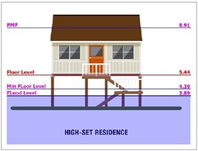
The PMF is the largest flood that could conceivably occur at a particular location, usually estimated from probable maximum rainfall.
Lismore Flood Risk Management Plan
The Lismore Flood Risk Management Plan is a comprehensive strategy developed to address the risks associated with flooding in the Lismore local government area.
The plan aims to reduce the impact of flooding on the community, the economy, and the environment through a range of measures, including flood mitigation works, land use planning, emergency management, and community engagement.
The Lismore Flood Risk Management Plan aims to minimise the exposure to flood hazard in Lismore’s developed areas and ensure that new development is compatible with the flood hazard and does not create additional flooding problems. Controls that apply to new development in the flood-prone urban areas of Lismore are in Chapter 8 of the Lismore Development Control Plan.